Vat Phou (Wat Phu)
How did builders spanning the Chenla kingdom to the Khmer Empire terrace a sandstone sanctuary roughly a mile up a steep, holy mountainside and pipe a natural spring through stone conduits to bathe a sacred linga, laying out the whole axis centuries before the same sacred-mountain cosmology reached its fullest expression at Angkor?
Why this rating?
- Construction difficulty
- 3/5
- Method uncertainty
- 3/5
- Capability gap
- 2/5
- Open questions
- 4/5
Terracing a sandstone sanctuary up a steep mountainside and engineering a gravity-fed stone conduit from a natural spring were real challenges but well within known Khmer stoneworking and hydraulic practice seen elsewhere in the region. What is genuinely unresolved is the site's deep chronology: how much of its earliest, pre-Angkorian phase reaches back to the 5th century or earlier, how the cult site evolved over eight-plus centuries of intermittent rebuilding, and how far the associated city of Shrestapura and its landscape-scale waterworks once extended.
Overview
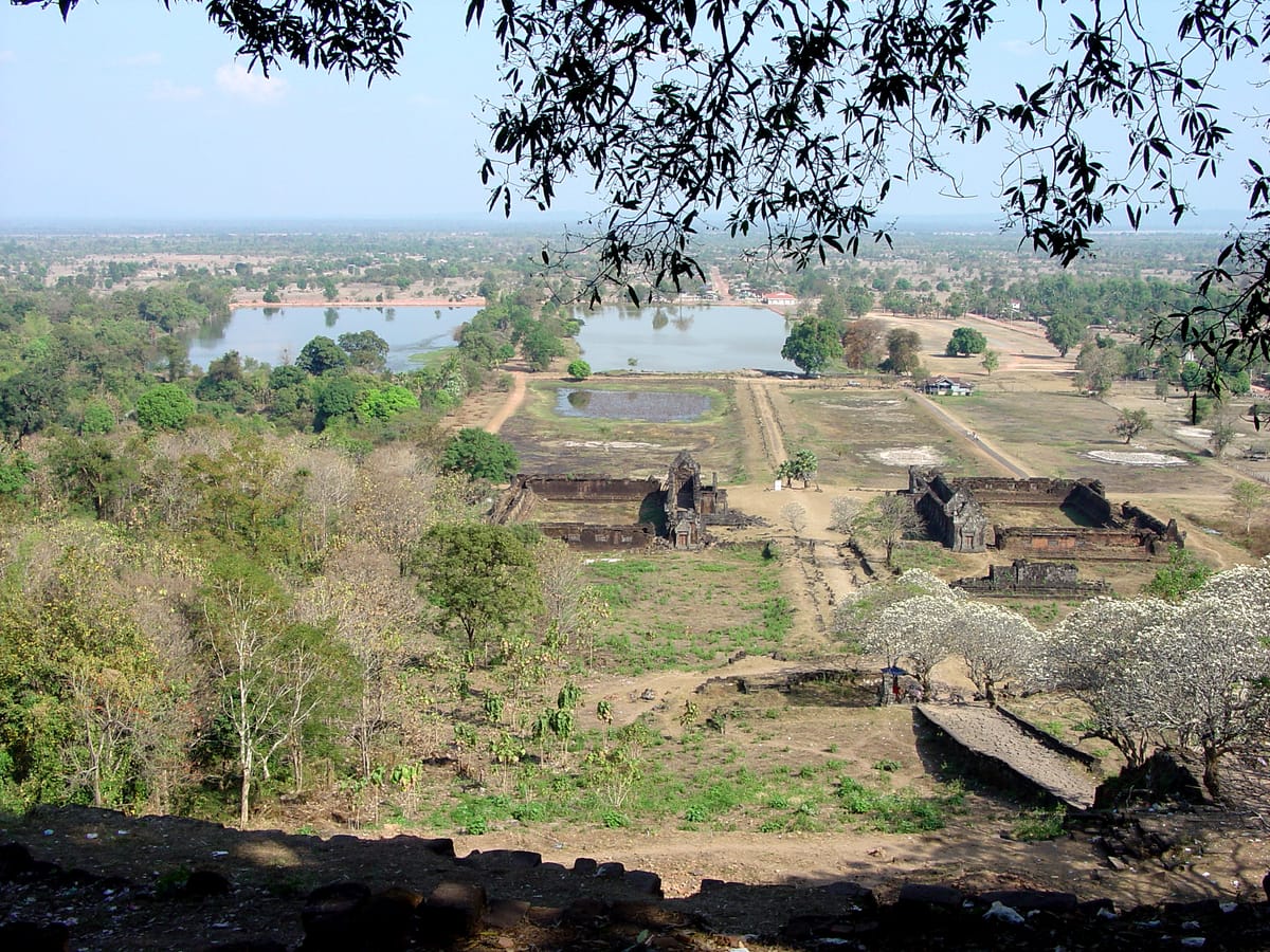
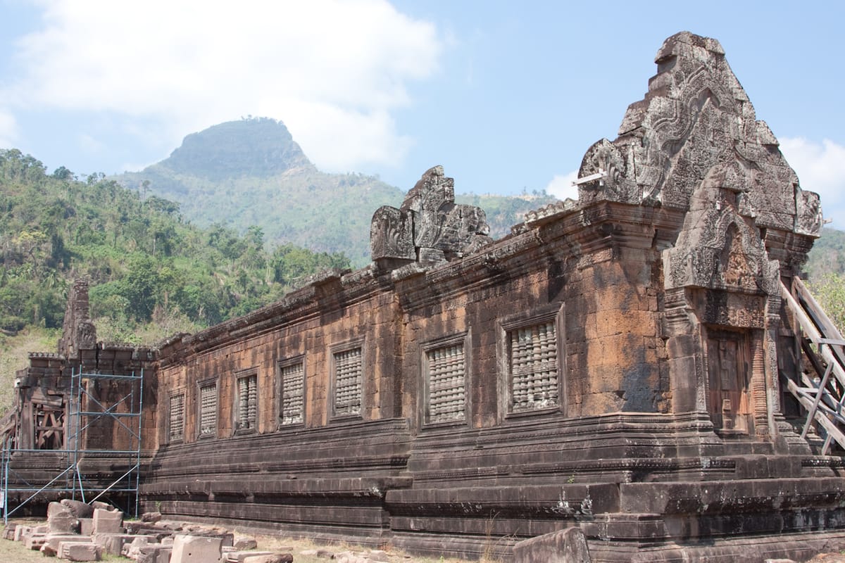
Vat Phou (also spelled Wat Phu, “Mountain Temple”) is a ruined Khmer Hindu temple complex on the lower slopes of Phou Kao, in Champasak Province in southern Laos, a few kilometers west of the Mekong River. It is built along a striking linear axis: a causeway and a sequence of stone terraces climb roughly 1.6 kilometers (about a mile) from the plain up the mountainside to a sandstone sanctuary set against the base of the peak, which the Khmer knew as Lingaparvata, “Linga Mountain,” because its summit was seen as a natural stone linga, the aniconic emblem of the Hindu god Shiva. The mountain’s sacred status appears to predate the temple itself, and the site was occupied, in some form, from at least the 5th century CE, making it one of the oldest continuously significant religious locations in mainland Southeast Asia — older than Angkor by several centuries. Most of the standing sandstone architecture visible today was built during the 11th to 13th centuries under the Khmer Empire, after which the sanctuary was adapted for Theravada Buddhist worship, a role it still serves; an annual festival draws pilgrims to the site every February. Together with the surrounding Champasak Cultural Landscape — the temple, the mountain, the plain, and the remains of an ancient city on the Mekong bank — Vat Phou was inscribed as a UNESCO World Heritage Site in 2001.
The Structure
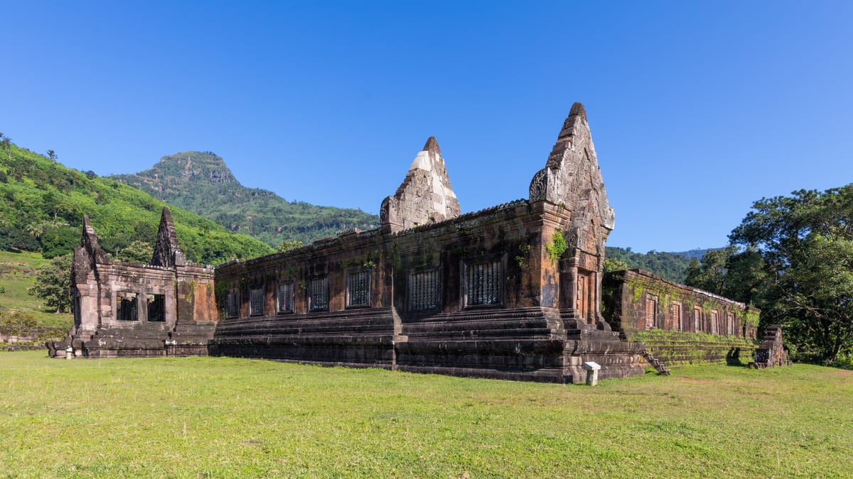
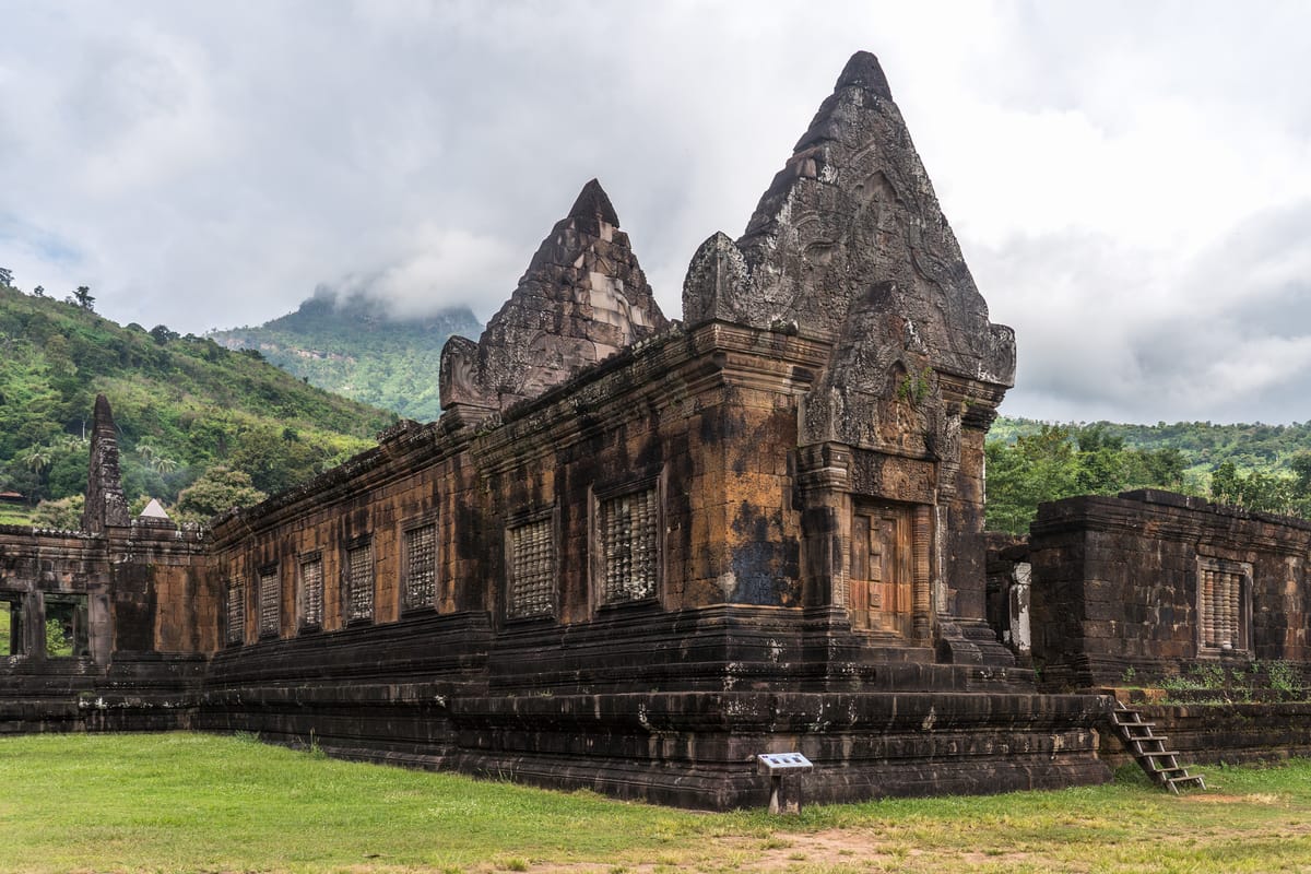
The temple’s cosmological logic is spatial: an axis running roughly east-west connects a former baray (reservoir) and the Mekong River at the bottom of the plain to the mountain sanctuary at the top, with the Khmer builders treating the entire landscape — river, plain, terraces, and peak — as a single sacred composition rather than an isolated building. Archaeological evidence suggests the location was already a site of ritual significance well before formal temple architecture appeared there: megalithic features possibly dating as early as the 2nd century BCE, including carved stone cells, a serpent-form stairway, and a boulder carved with a crocodile motif, have been identified on the mountainside. By the late 5th century the site was associated with Shrestapura, a city on the Mekong’s bank linked to the pre-Angkorian Chenla kingdom, and an early Sanskrit inscription found nearby records a ruler named Devanika establishing a sacred tirtha (a holy bathing place) in the area — among the earliest textual evidence of Khmer-influenced religious activity in the region. A brick sanctuary was built at the site in the 7th century. The complex was then rebuilt and expanded repeatedly over the following centuries as the Khmer Empire grew, with most of the surviving sandstone construction — the causeway, the terraced approach, two large quadrangle buildings flanking the path (often called the north and south “palaces,” likely used for ceremonial or administrative purposes rather than habitation), and the sanctuary itself — dating to the 11th through 13th centuries. Carved boulders along the route, popularly known as the Elephant Stone and the Crocodile Stone, and a scatter of other shrines and pavilions on the forested slope attest to a religious landscape more extensive than the main axis alone. From the late 13th century the upper shrine was rededicated to Buddhism, and the linga that had occupied its inner sanctum was eventually replaced with a Buddha image, a transformation mirrored at other Khmer sites, including Angkor, as Theravada Buddhism spread through the region.
How Was It Built?
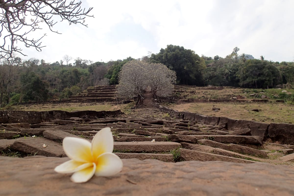
The visible temple is built almost entirely of sandstone and laterite, the two workhorse stones of Khmer religious architecture: laterite, a porous iron-rich rock that hardens on exposure to air, for foundations and less visible structural work, and sandstone, finer-grained and better suited to carving, for the terraces, staircases, and decorated surfaces. Builders cut and set stone in courses up the natural slope of the mountain, creating seven stone terraces connected by stairways that climb toward the sanctuary, a construction approach adapted specifically to the site’s steep, uneven terrain rather than a flat building platform of the kind used at most other Khmer temples. The sanctuary’s sandstone walls carry lintels and pediments carved with Hindu religious scenes and figures in the Khmer decorative tradition, work of the same craft lineage responsible for the later relief carving at Angkor. Behind and above the sanctuary, a natural spring emerges from the hillside; Khmer builders channeled it through a stone conduit into the shrine itself, where the water anointed the linga at the heart of the temple in a continuous act of ritual purification, turning the mountain’s own water source into part of the building’s function rather than a separate convenience. Building on a slope this steep, over a project that unfolded across centuries, required Khmer engineers to solve problems of terracing, drainage, and water routing specific to a mountainside sanctuary — distinct from, though related to, the flatland hydraulic engineering the same civilization later deployed at a much larger scale around Angkor.
The Mainstream View
Historians and archaeologists treat Vat Phou’s broad outline as well established: a mountain already regarded as sacred, owing to its linga-shaped peak, became the site of a religious settlement by the Chenla period, was progressively formalized in brick and then sandstone architecture over several centuries, and was finally rebuilt as a major stone sanctuary by the Khmer Empire between the 11th and 13th centuries, following the same Hindu temple-mountain cosmology that would later be expressed on a grander scale at Angkor. The site’s inscriptions, its architectural sequence (traceable through comparison with securely dated Khmer monuments elsewhere), and its integration into the wider Champasak Cultural Landscape are consistent with this framework, and UNESCO’s 2001 inscription explicitly recognizes Vat Phou as a rare surviving example of an entire sacred landscape — river, plain, and mountain — planned as a unified composition. Scholars view the hydraulic detail of the spring-fed conduit and the terracing up the mountainside as a coherent engineering response to the site’s topography, executed with the same sandstone-and-laterite building tradition, tools, and craft organization documented at other Khmer sites. None of this is seriously in dispute; ongoing scholarly work focuses on refining the chronology and extent of construction phases rather than questioning who built the temple or in what tradition.
The Open Case
What remains genuinely unresolved at Vat Phou is less the “how” of any single technique and more the deep timeline of the place. The earliest features on the mountainside — possible megalithic stonework tentatively dated to the last centuries BCE, the layered rebuilding from a 7th-century brick sanctuary through to the sandstone temple standing today — are pieced together from a thin scatter of archaeological and epigraphic evidence, and specialists continue to debate exactly how early formal construction began and how continuous the site’s religious use was across its long pre-Angkorian centuries. The extent of Shrestapura, the ancient city associated with the temple on the Mekong’s bank, is also only partly understood; much of the surrounding cultural landscape, including its planned settlements and water infrastructure, remains under archaeological investigation. And while the terracing and the spring’s stone conduit are explicable in principle, the finer engineering choices — how builders planned and sequenced construction up a live, uneven slope over a project stretching across dynasties, and how reliably the ancient conduit system functioned across the centuries of the temple’s active use — are reconstructed from surviving stonework and comparison with better-documented Khmer sites rather than from any surviving building record. These are open questions of chronology, extent, and engineering detail, not open questions about who built Vat Phou or why: every strand of evidence — inscriptions, architectural sequence, and comparative Khmer archaeology — points to a religious landscape shaped by human hands across many centuries, working an already-sacred mountain into stone. The wonder here is less “how could they” than “how long, and how carefully” — a site whose story is still being assembled one terrace, one inscription, one excavation at a time.
Sources
Gallery