The Pont du Gard
How did Roman surveyors, working with a water-level trough and a sighting frame, lay out a 50-kilometre water channel that falls only about a dozen metres end to end — and then carry it across a river gorge on three tiers of dry-laid stone that drop just 2.5 centimetres from one bank to the other?
Why this rating?
- Construction difficulty
- 4/5
- Method uncertainty
- 3/5
- Capability gap
- 2/5
- Open questions
- 3/5
Roman arch construction, quarrying and block-hoisting are well documented, and the bridge itself carries visible evidence of how it was built — projecting scaffolding corbels, setting-out marks, numbered blocks — so there is no real gap between the result and what Romans are known to have been able to do. What stays genuinely unresolved is the surveying: how a 50-kilometre channel was levelled to a fall of roughly a quarter-metre per kilometre, and in places to millimetres per hundred metres, using a chorobates and a groma, is reconstructed from Vitruvius and from the finished line rather than from any surviving record — and the date of the work, the identity of its architect, and how the gradient was arrived at are all still argued over.
Overview
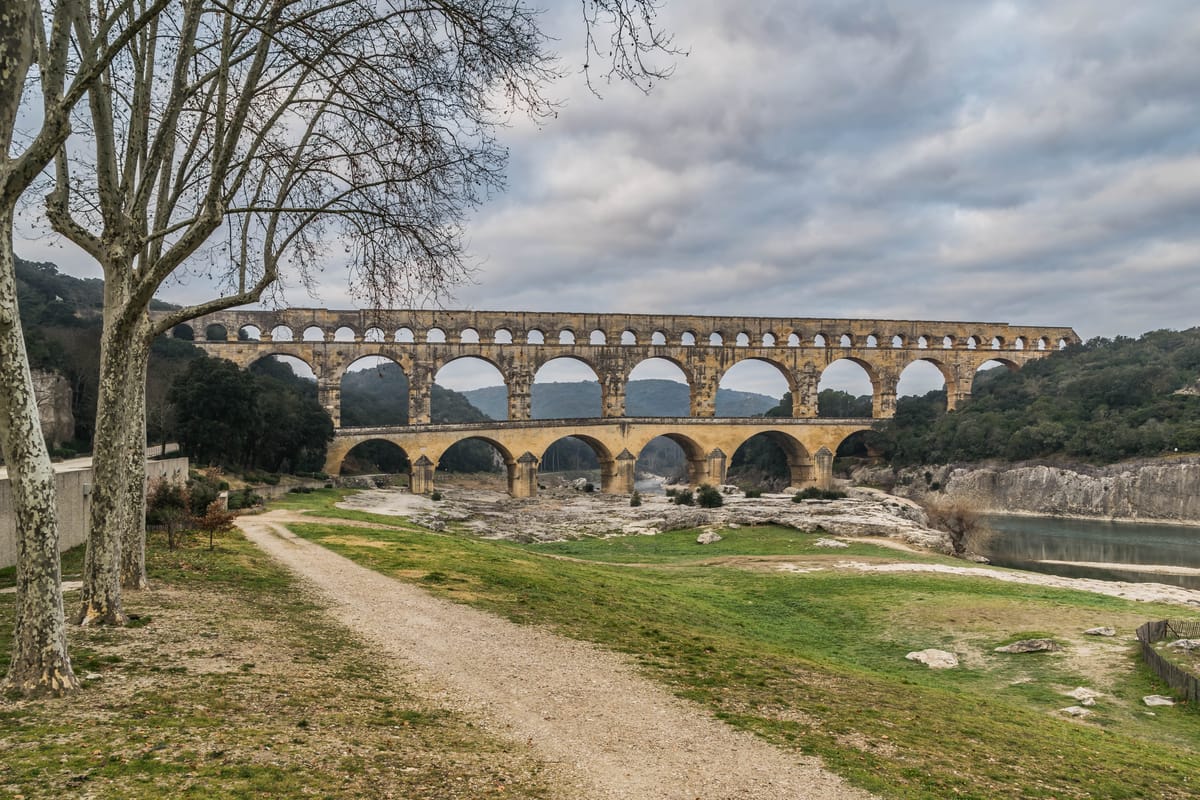
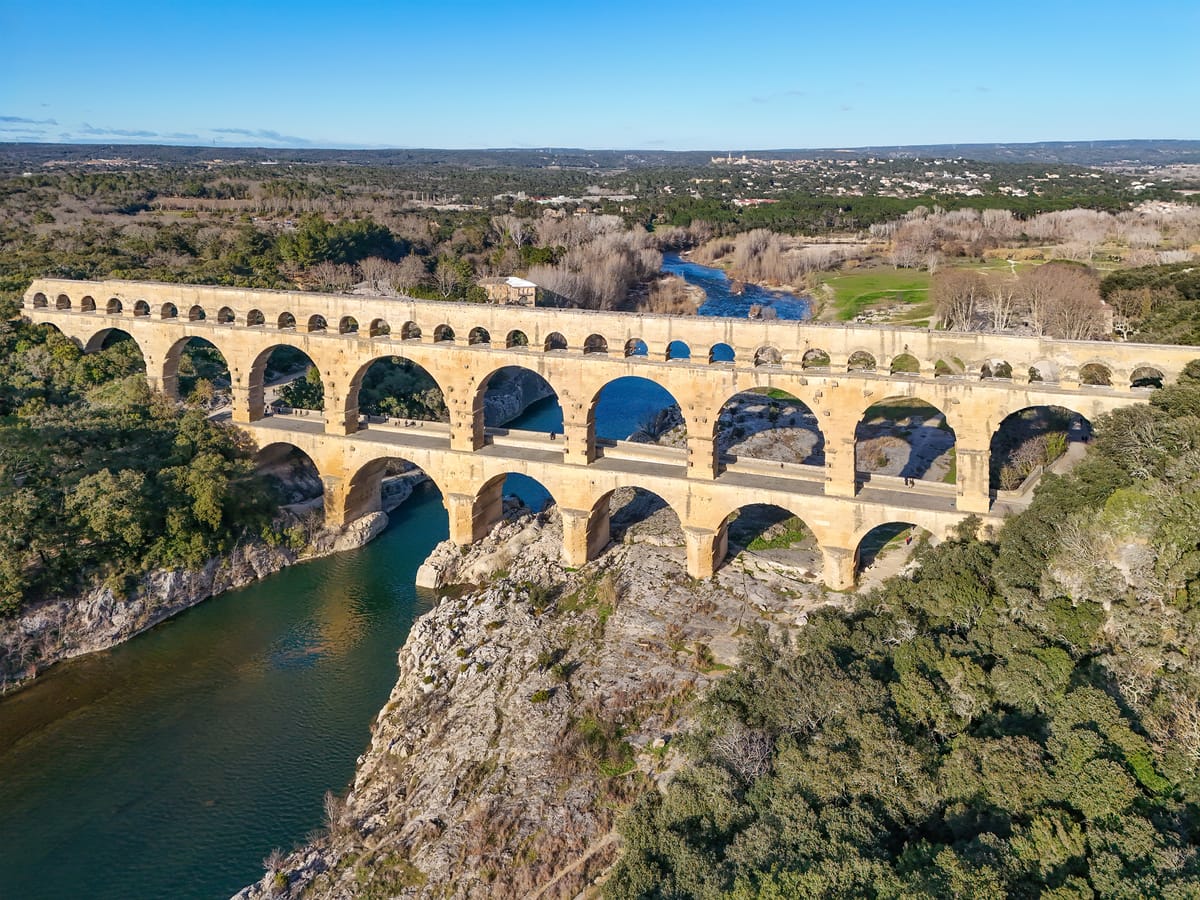
The Pont du Gard stands in a wooded gorge in Occitanie, about twenty kilometres northeast of Nîmes, where the Gardon river cuts through low limestone hills. It is the tallest Roman aqueduct bridge still standing — roughly 48.8 metres from the low-water river to the top of its third tier — and, at about 275 metres along its uppermost arcade, one of the longest. Three superimposed rows of arches carry it across the valley: six heavy arches at the bottom, eleven above them, and a long, slender arcade on top. It is important to understand what it is not: it is not a bridge in the ordinary sense, and it was never built to carry people or carts. It is a piece of plumbing. The whole enormous structure exists to hold one covered stone channel, about 1.8 metres high and 1.2 metres wide, at a very specific height above the valley floor, so that water flowing through that channel from a spring at Uzès would continue to fall — gently, continuously, and without ever being pumped — all the way to the Roman colony of Nemausus, modern Nîmes. The bridge is a single spectacular episode in a fifty-kilometre aqueduct that is otherwise buried, tunnelled, or hidden in trenches for almost its entire length. It has been a UNESCO World Heritage Site since 1985, and it is one of the most visited monuments in France — but the reason engineers keep coming back to it is not the arches. It is the gradient.
The Structure
Nemausus was a prosperous colony of Gallia Narbonensis, the long-Romanised province along the Mediterranean coast of southern Gaul, and like every ambitious Roman city it wanted running water: for its public fountains, its baths, its latrines, and for the private houses of citizens wealthy enough to be granted a tap. The water came from the Fontaine d’Eure, a karstic spring just outside Uzès. Uzès lies only about twenty kilometres from Nîmes in a straight line, but the direct route is blocked by the Garrigues hills, and the source sits barely a dozen metres above the point where the water had to arrive. So the aqueduct takes an enormous detour — a winding, roughly V-shaped course of about fifty kilometres, hugging contours, ducking into tunnels, running along the sides of valleys, and crossing the Gardon on the Pont du Gard. The bridge’s three tiers are built on a descending scale of mass: the bottom tier’s six arches span from about 15 to 24 metres, the widest leaping the river channel itself, on piers some six metres thick; the middle tier carries eleven arches on four-metre piers; the top tier originally had 47 small arches, of which 35 survive, on piers only three metres thick. The stone is a soft, coarse, shelly local limestone — the pierre de Vers — quarried at Estel, a Roman quarry on the bank of the Gardon only some 600 to 700 metres downstream, where the negative impressions of extracted blocks are still visible on the rock face. Estimates put the bridge’s stone at roughly 21,000 cubic metres and something like 50,000 tonnes, with the largest individual blocks weighing around six tonnes. Inside the upper arcade runs the specus, the channel proper: dressed masonry walls, a concrete floor, and a waterproof lining. Modern analysis of its red coating found not the cattle blood and fig juice that Vitruvius recommended, but iron-oxide-rich red sand mixed with lime. The aqueduct is thought to have delivered on the order of 40,000 cubic metres of water a day, with a journey time from spring to city of about a day and a night.
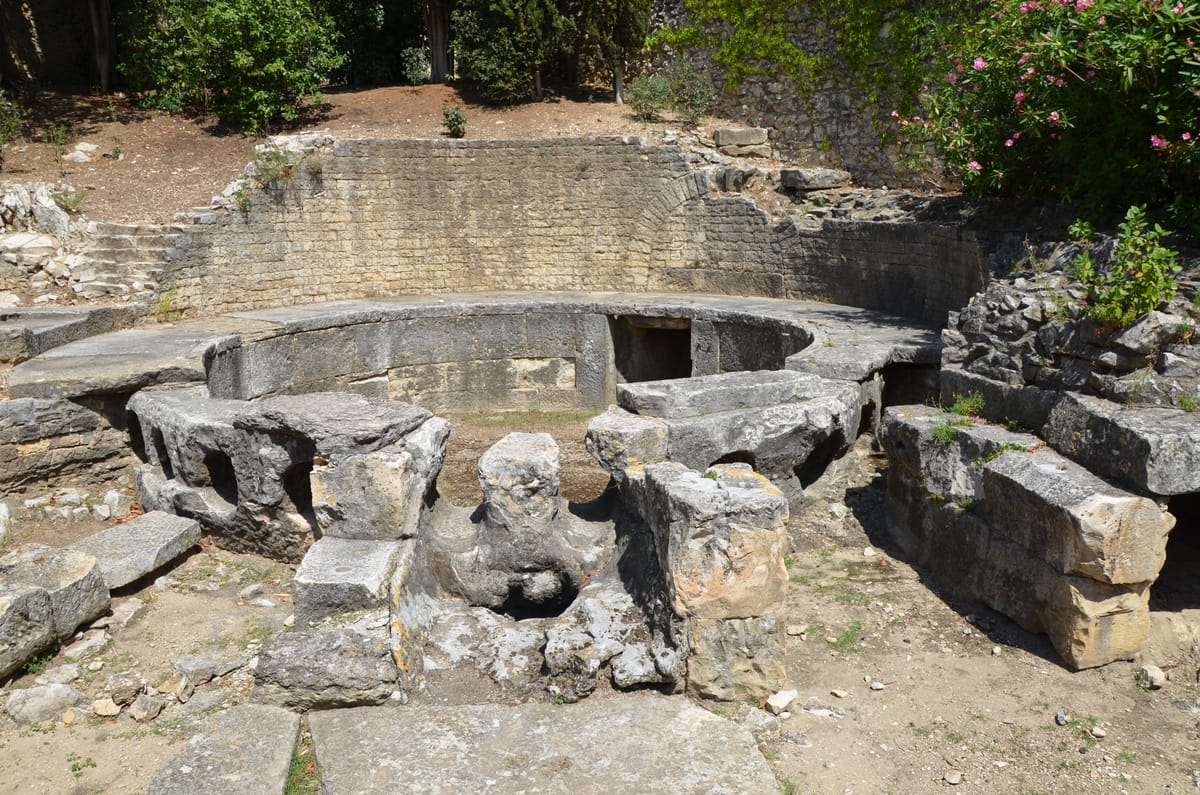
The bridge outlived the system it was built for. Maintenance of the channel by the circitores — the workers who scraped out the limescale — seems to have lapsed after the fourth century CE, and mineral deposits built up inside the specus to as much as half a metre thick on each wall, choking the flow; the aqueduct is generally reckoned to have stopped functioning by about the sixth century. The bridge was then repurposed by everyone who came after. Medieval lords of Uzès levied a toll on people crossing it. In the 1620s the Duke of Rohan had one side of the second-tier piers cut back by roughly a third of their thickness so that artillery could pass along them — a piece of vandalism that came close to costing the bridge its stability. Between 1743 and 1747 the engineer Henri Pitot built a road bridge flush against the lower tier, which is why the bottom level today looks oddly thickened. By 1835 the inspector of historic monuments, Prosper Mérimée, reported it in serious danger of collapse; a major restoration under the architect Charles Laisné, backed by Napoleon III, ran through the 1850s. The road traffic was finally removed and the site pedestrianised between 1996 and 2000.
How Was It Built?
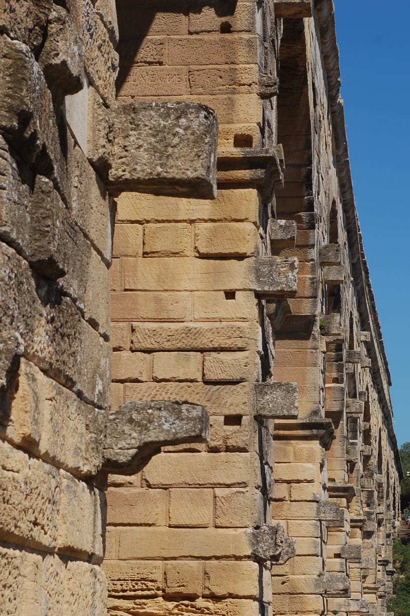
Almost uniquely among ancient monuments, the Pont du Gard still displays its own construction drawings. Look along the piers and you see hundreds of blocks left deliberately projecting from the face — uncut corbels that carried the timber scaffolding and the centring frames on which each arch was turned. The Romans simply never trimmed them off. Other blocks carry cut setting-out marks and carved instructions telling the gang where each stone belonged: fronte dextra, fronte sinistra — front right, front left — the ancient equivalent of numbered flat-pack parts, which tells you the blocks were dressed at or near the quarry and assembled in a planned sequence rather than fitted by trial and error on site. The stone was moved from Estel, less than a kilometre away, and lifted by block-and-tackle, by sheerlegs worked with a windlass, and for the heaviest pieces by human-powered treadwheel cranes; excavations after the Gardon’s floods in 2002 scoured the banks and exposed remains of Roman hoisting gear at the working level. The arches of the two lower tiers were laid essentially dry. The blocks were cut accurately enough that friction and the compressive weight of the structure hold them; mortar appears only in the top tier and in the channel itself. Rough modern estimates suggest a workforce in the region of 800 to 1,000 and a construction period of perhaps fifteen years for the whole aqueduct, at a cost of tens of millions of sesterces.
The harder work, though, happened before a single stone was cut. Roman surveyors had a groma, a cross-frame with plumb lines for setting out straight lines and right angles; a chorobates, essentially a long, heavy wooden bench with a water trough cut into its top for reading level; graduated poles; and wax tablets. With these they had to find and mark a route across fifty kilometres of broken limestone country along which water would run downhill continuously and never, anywhere, run uphill — because a single reversed section anywhere along the line would pond the water and kill the flow. The total fall available from spring to city is tiny: sources put it at somewhere between roughly 12 and 17 metres depending on which points are measured, an average of around a quarter of a metre per kilometre. And that average conceals extremes. Some stretches near the source and near Nîmes drop by about 45 to 67 centimetres per kilometre; long intermediate sections drop by less than a tenth of that. On the winding reach between the Pont du Gard and Saint-Bonnet the channel falls on the order of 7 millimetres per hundred metres. Across the bridge itself, the fall is about 2.5 centimetres — over a structure whose channel runs some 456 metres including its approaches. That is a slope of roughly one in eighteen thousand, achieved with a water trough and a sighting frame.
The Mainstream View
There is no serious dispute about who built the Pont du Gard or why. It is Roman, it is a water bridge, and it is a textbook demonstration of the Roman arch, the Roman quarry, and the Roman specus. The only substantial argument is about when. For centuries the aqueduct was credited to Marcus Vipsanius Agrippa — Augustus’ general, son-in-law, and the great patron of Roman waterworks — during his time in Narbonensis around 19 BCE, and this attribution still turns up on signage and in older books. Excavations from the 1980s onward have steadily undermined it. The aqueduct’s builders had to bypass tunnels of Augustan date, which is awkward if the aqueduct is itself Augustan; and coins recovered from the outflow catchments at Nîmes are no older than the reign of Claudius (41–54 CE). A team led by the archaeologist Guilhem Fabre argued on this basis that the aqueduct was completed around the middle of the first century CE, and a construction window of roughly 40 to 60 CE is now the mainstream position — though no precise date is fixed and the older attribution has never entirely died. The architect is unknown. One inscription found on the structure, sometimes read as mensura — a measurement — may be the nearest thing to a signature the builders left, and it is a measurement, not a name. As for how it stands up: the consensus is unromantic and correct. Dry-laid limestone in compression, piers founded on rock, arches sized to the spans they cross, and scaffolding corbels left in place because nobody was paid to remove them.
The Open Case
What keeps the Pont du Gard interesting is not whether Romans could build arches. They plainly could, everywhere, for centuries. It is the precision of the line the arches were built to hold. Consider what the surveying problem actually demanded: a continuous, monotonic descent over fifty kilometres of hills, tunnels, and valley sides, with a total budget of about a dozen metres of height, and with sections where an error of a couple of centimetres over a hundred metres would have reversed the flow. The instruments available — Vitruvius describes the chorobates as being trusted over the more portable alternatives precisely because wind could disturb them — were a trough of water on a bench and a frame with plumb bobs. There was no theodolite, no optical levelling, no way to check a cumulative error except by walking the line again. And yet the aqueduct worked, for something like four hundred years. How was that tolerance actually achieved on the ground? Was the gradient designed in advance from a full survey, or found iteratively, section by section, by crews who levelled forward and corrected as they went? The evidence for either is thin, because the surveyors’ working records do not survive; what survives is only the answer, cut in stone. The structure has even had one of its supposed pieces of genius quietly taken away: the slight bend in the upper tiers was long read as a deliberate engineering refinement, until a microtopographic survey in 1989 showed that the bridge’s stone simply expands and contracts by around five millimetres a day under the sun, and the curve is that. Which leaves the real wonder undisguised. Not a lost technology, and not a secret — just an ordinary, extraordinary fact: that two thousand years ago a group of people whose names nobody recorded looked at fifty kilometres of hill country, worked out by eye and by water where the ground fell away by a hand’s breadth per kilometre, and were right.
Sources
- Wikipedia — Pont du Gard
- UNESCO World Heritage Centre — Pont du Gard (Roman Aqueduct)
- World Heritage Journeys of Europe — Uncovering Pont du Gard's archaeological secrets
- Water (MDPI) — Roman Hydraulic Engineering: The Pont du Gard Aqueduct and Nemausus (Nîmes) Castellum
- Archaeology Travel — The Nîmes Aqueduct: Uzès, Pont du Gard & Castellum Aquae
- Britannica — Pont du Gard
- roman-empire
- aqueduct
- france
- hydraulic-engineering
- roman-surveying
- gallia-narbonensis
- nimes
- unesco-world-heritage
- dry-stone-masonry
- first-century-ce
Gallery