Nazca Lines
How did a people with no aircraft lay out animal figures and dead-straight lines running for kilometres across the desert — forms whose full shape is only legible from the air — with such control of scale and proportion, and what were they for?
Why this rating?
- Construction difficulty
- 3/5
- Method uncertainty
- 2/5
- Capability gap
- 3/5
- Open questions
- 4/5
The physical act — clearing shallow surface stones — is simple, but holding a straight line for kilometres and scaling a proportioned animal figure hundreds of metres across is a genuine surveying feat, though experiments with stakes and cords have reproduced even the largest figures without aerial help, so the method itself is fairly well understood. What remains sharply debated is not how the lines were drawn but why: astronomical calendar, water and fertility ritual, and ceremonial processional paths are all still argued, and modern AI-assisted surveys keep enlarging the known catalogue.
Overview
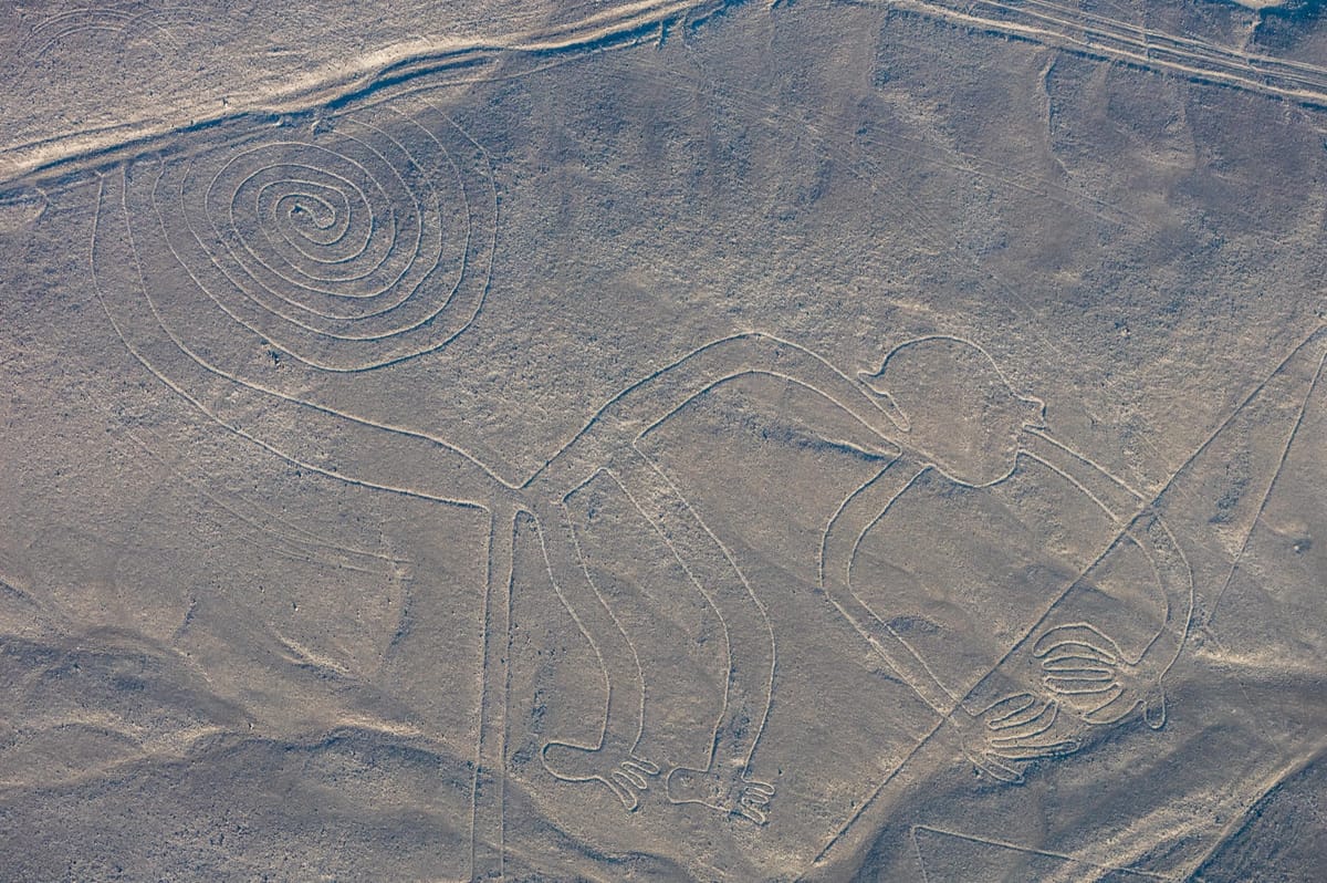
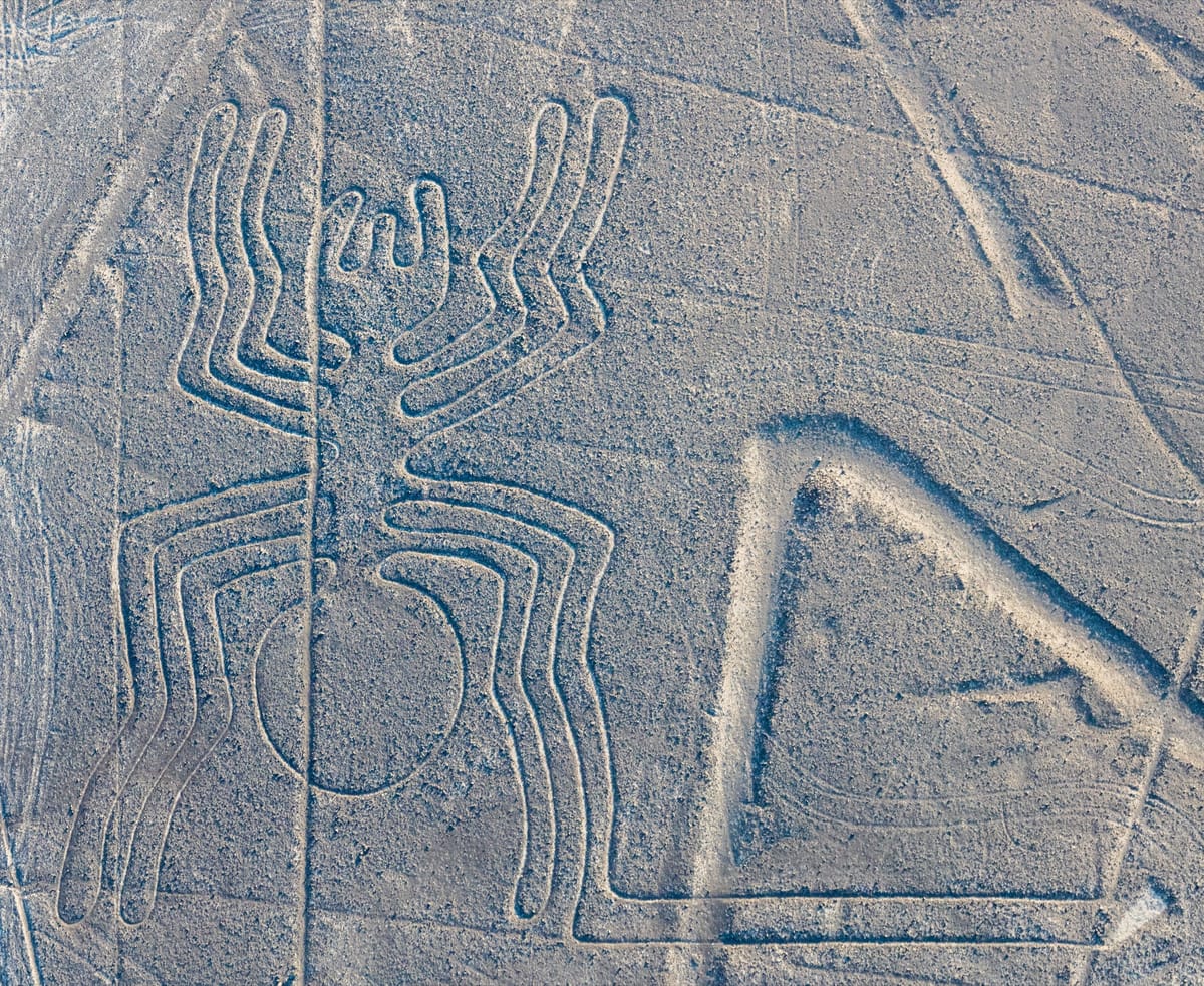
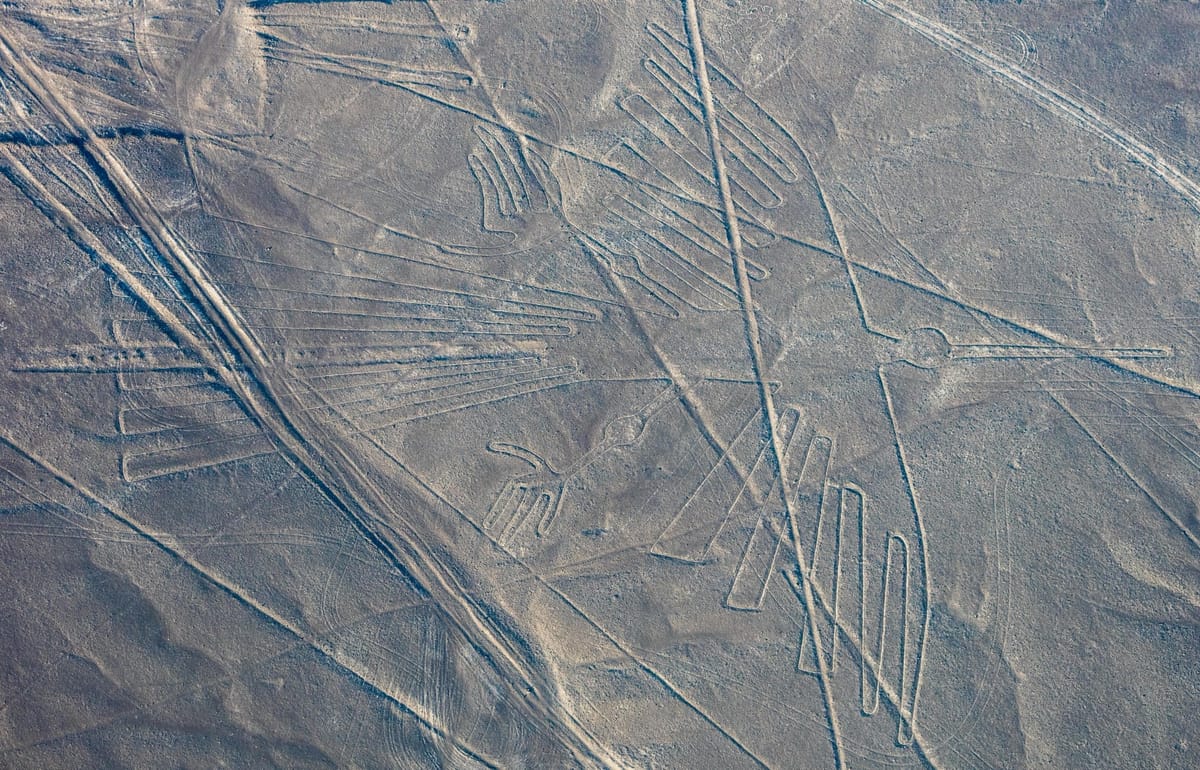
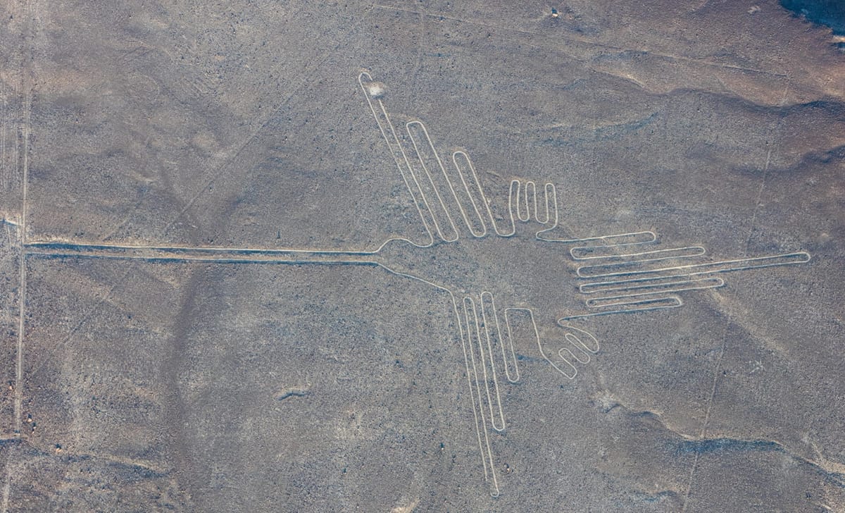
The Nazca Lines are a vast collection of geoglyphs — designs made directly on the ground — etched across roughly 50 square kilometres of arid coastal plateau in the Nazca Desert of southern Peru, about 400 kilometres south of Lima in the Ica Region. Created by the Nazca culture between roughly 500 BCE and 500 CE, with the earliest examples attributed to the preceding Paracas culture, they comprise more than a thousand individual figures: over 800 dead-straight lines, some running unbroken for kilometres; around 300 geometric shapes such as triangles, trapezoids, and spirals; and some 70 biomorphs — stylised animals and plants including a hummingbird, a monkey, a spider, a condor, a pelican, a whale, and a pair of hands. The lines were made by a remarkably simple technique: scraping away the dark, iron-stained pebbles that cover the desert surface to expose the lighter-coloured ground a few centimetres beneath, so that each figure reads as a pale line against a darker background. Their most famous quality is also their central puzzle — the largest figures span the length of several football fields and resolve into coherent images only when seen from high above, an aerial vantage the Nazca themselves never had. Preserved for two millennia by one of the driest, most windless climates on Earth, the lines were inscribed on the UNESCO World Heritage List in 1994 and remain the subject of active archaeological research, with new figures still being discovered.
The Structure
The geoglyphs sit on the pampa, a flat, stony tableland between the Nazca and Ingenio river valleys, where the Nazca people lived as a farming society dependent on a fragile network of seasonal rivers and underground water in an almost rainless landscape. Their culture is known for finely painted polychrome pottery and elaborate textiles, and for the ceremonial centre of Cahuachi, a complex of adobe mounds near the lines that appears to have been a focus of pilgrimage and ritual. The geoglyphs fall into three broad types. The straight lines are the most numerous and the most extreme in scale: some extend for many kilometres across the desert, crossing dry riverbeds and low ridges while barely deviating, and they range from about 30 centimetres to more than a metre wide. The geometric figures include long trapezoids and triangles — some resembling cleared “runways,” though they predate flight by two thousand years — as well as zigzags and spirals. The biomorphs are the best known: the hummingbird is about 93 metres long, the monkey roughly 93 metres across with a great spiralling tail and a hand drawn with nine fingers, the spider around 46 metres, and the condor a bird figure well over 100 metres from wingtip to wingtip. Many of the animal figures share a striking property — each is drawn as a single continuous line that never crosses itself, entering and leaving the figure at nearly the same point, so that the whole outline could in principle be walked from end to end. The lines themselves are shallow, typically only 10 to 30 centimetres deep, which is part of why their survival is so remarkable.
How Was It Built?
The making of a Nazca line required no quarrying, no lifting, and no metal. The desert floor is covered by a layer of pebbles darkened over millennia by a coating of iron and manganese oxides — a natural “desert varnish” — lying over paler, yellowish-grey subsoil. To draw a figure, the builders simply removed the dark surface stones along the intended path and piled them to the sides, exposing the lighter ground beneath as a contrasting line. Because the climate is exceptionally dry, stable, and almost windless, and because the exposed soil contains gypsum and lime that hardens with the region’s morning dew into a protective crust, these shallow scrapings have endured for up to two thousand years with little erosion. The harder question is not how the stones were cleared but how the figures were laid out with such control. Archaeologists have found wooden stakes driven into the ground at the ends of some lines — a few radiocarbon-dated to the Nazca period — consistent with a method using fixed posts and taut cords to sight and hold a straight line over long distances. For the animal figures, the leading explanation is proportional scaling-up: the maker works from a small preliminary drawing and enlarges it onto the desert using a grid, a central reference point, and measured cords, transferring the design section by section. This does not require seeing the finished figure whole, only working outward accurately from known points.
The Mainstream View
Mainstream archaeology regards the Nazca Lines as an achievement of careful surveying and organised communal labour, not of any lost or exotic technology. The technique of removing surface stones is directly observable in the lines themselves, and the layout methods have been tested experimentally. In one well-known 1982 demonstration, the investigator Joe Nickell and a small team reproduced a large Nazca figure — the condor — on an American field using only wooden stakes, cord, and simple sighting, working from a scaled drawing and without any aerial guidance, and achieved a result faithful enough to answer the “impossible from the ground” objection. Estimates suggest that even the biggest figures could have been laid out by modest groups over days or weeks, and the whole corpus accumulated across many centuries rather than in a single campaign — stratigraphy on the pampa shows later figures cutting across earlier lines, evidence of a landscape reworked again and again. That the images are best appreciated from above does not require that their makers ever flew: many are visible in outline from the surrounding foothills, and the act of creating and using them — rather than viewing them whole — may have been the point. Modern survey work continues to reinforce the human, cumulative picture: since the 2010s, teams using aerial imagery, drones, and machine-learning analysis have identified hundreds of additional, often smaller geoglyphs, including a 2024 study that used AI to help nearly double the known number of “relief-type” figures.
The Open Case
What keeps the Nazca Lines genuinely mysterious is not how they were drawn — that is fairly well understood — but why. No written records survive from a culture that left no script, and the leading explanations remain unresolved after a century of study. The earliest scientific theory, developed by Paul Kosok and the mathematician Maria Reiche, who devoted more than fifty years to mapping and protecting the lines, held that they formed a giant astronomical calendar, with lines pointing to the rising and setting of the sun, moon, and stars at significant dates. Later statistical testing by archaeoastronomers, notably Gerald Hawkins and Anthony Aveni, found that the alignments were no more frequent than chance would predict, and the strict astronomical reading is now largely set aside. A second major hypothesis, associated with Johan Reinhard and others, ties the geoglyphs to water and fertility in a desert where water was everything: many lines appear to lead toward sources of water or to ceremonial mounds, and the figures and long straight paths may have been walked in rituals appealing to mountain and water deities for rain and abundance. Others emphasise the lines as processional and social pathways linking communities and shrines, their meaning bound up in the act of moving along them. It is entirely possible that different figures and lines served different purposes, and that those purposes shifted over the many generations the pampa was in use. The enduring wonder is real: a people working entirely from the ground, without flight or writing, imposed precise, kilometre-scale order on a desert to make images and pathways whose full form they could never step back to see — and left us to work out, from the marks alone, what they were trying to say, and to whom.
Sources
- UNESCO World Heritage Centre — Lines and Geoglyphs of Nasca and the Pampas of Jumana
- Wikipedia — Nazca lines
- Encyclopaedia Britannica — Nazca Lines
- World History Encyclopedia — Nazca Lines
- Wikipedia — Nazca culture
- Smithsonian Magazine — The Mystery of the Nazca Lines
- Sakai et al., PNAS (2024) — AI-accelerated Nazca survey nearly doubles the known relief-type geoglyphs
- Anthony F. Aveni — Between the Lines: The Mystery of the Giant Ground Drawings of Ancient Nasca, Peru (University of Texas Press, 2000)
Connected findings
- Patterns Too Big to See — In Ohio, the Hopewell laid out circles and an octagon so exact they frame the moon's 18.6-year cycle. In Peru, the Nazca drew animals the length of football fields. Neither people could ever stand back far enough to see the whole of what they made.
On screen
- The Lines You Walked — A 1993 SNES adventure sent players into the Nazca Desert itself — not to fly over the geoglyphs, but to search one out on foot.
Gallery